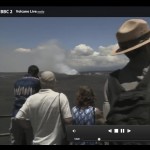
So if you want to come and venture into an active volcano, follow me…:
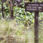
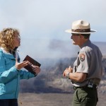
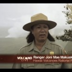
This tour will last approximately 2.5 to 3 hours, taking us from the Crater Rim here at the Visitors Center into the main caldera of Kilauea and to eyelevel with the active eruption from Halema’uma’u crater, hence the name “Halema’uma’u trail“. It has been in use since 1846, and we will follow in the footsteps of the old adventurers heading for a molten lava lake that was often to be found inside Halema’uma’u at that time. My name is Michael, and I will be your ranger for the hike today.
As a brief outline for the program, which I called “changescapes” for the ever changing landscapes that we will encounter, let me offer the following information:
– The 2.5-3 hours tour will be both inside the rain forest and on open lava and some patches of open, green terrain. Check that you all have comfortable walking shoes and protective clothing for both sun and rain, as the weather can change frequently up here at the summit. Also bring water and some trail snacks.
– We are currently located 4000′ ft elevation (1225 m ü.M.), but will descend 425′ (130m) down onto the caldera floor, encountering the 1974 lava flows.
– Along the way, we will find some stairs on the trail, unstable landslide areas next to the trail and sharp edges of lava. Please stay on the trail.
If you are prepared and ready to go, follow me.
Stop 1: The changing view across Kilauea
This measurement marker from ancient times is said to have been selected for the great view across the entire volcano for the US topopgraphical measurements. This place used to have one of the typical, triangle-shaped cones on top of it. Now, what can you see today? Right – nothing. This is how quickly the landscape has changed. Actually, I am quite glad it has, because this will help me in the outline of my talk, leaving out the view of the caldera and the ongoing eruption at Halema’uma’u for a little while, until we exit the rainforest!

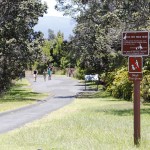
Trailhead sign, towards Halema'uma'u trail, Hawai'i Volcanoes National Park
Stop 2: Ferns of the Rainforest
As the volcano and the landscapes around it have changed significantly over the past few hundred years, so has the rain forest. It has been destroyed and pioneered back out again many times, and this part is probably less than 200 years old, built on a thin layer of volcanic ash and soil.
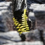
In this upper part of the rainforest, we find many of the abundant endemic or native ferns of Hawai’i. Endemic means that certain species are found nowhere else on earth than in one particular spot, and in Hawai’i, over 90% of all native species are endemic. The following three ferns are easy to distinguish as follows:
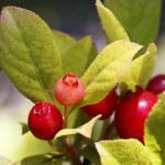
– Hapu’u Pulu (Cibotium glaucum) ferns are large tree ferns that are called “walking tree ferns” because they tend to crash under their own crown weight and resprout at the end of the nurse log – they, like so much else on Hawai’i, grow very slowly, only approximately 12 inches or one foot per decade. Take a guess, then, how old this one may be?!
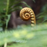
– Ama’u ferns can be distinguished from the Hapu’u ferns by their different mechanism in branching. While the Hapu’u branches in three (stem, branch stem, leaves), the Ama’u branches only one, having two elements to the crown, as you can see here (demonstrate at one of the ferns). The youngest branches often experience what is called “tropical flush”, red patches of sun protection – or a glowing punishment from Pele… Ama’u ferns don’t have the soft, velvety fuzz but rather a coarse skin similar to a pig’s back – we come to those two stories a little later…

Young fiddlehead of Ama'u fern, Hawaii Volcanoes National Park
– Uluhe ferns are native but not endemic to Hawai’i. Especially their youngest stages are easy to identify, with their single stem in deep purple fully curled up at the top and then branching always in multiples of two. When grown, their leaves are much thinner and slimmer than the ones from the other two ferns.

Uluhue hearts

Both young fiddlehead and grown fern of Uluhe, Hawaii Volcanoes National Park
Stop 3: The trees
– While one of our famous hardwood trees used for the important Hawaiian outrigger canoes manufacturing cannot be found in this section of the tree, I will point it out later – the Koa.
– However, two very common trees in this area of the park abund here, especially this one – Ohia Lehua, a really special tree with a Hawaiian legend or story associated with this, which I want to share with you as we go along. In addition, we find Iliahi, or Sandalwood here. The tree almost got extinct some time ago when it was cut down and used for its fragrance and beautiful pieces of furniture. At that time, there was virtually no control on the harvesting of Sandalwood, and the high demand especially in Asia, making Sandalwood once of the most cherished and expensive fragrances, brought it to the brink of extinction.

Leaves of Iliahi with tropical flush along Crater rim trail, Hawai'i Volcanoes National Park
Stop 4: The problem of invasive species
A big impact on the look of the landscape in and around Hawai’i Volcanoes National Park is attributed to invasive species, those that were introduced by humans, don’t naturally belong here and have caused havoc due to their extensive and rapid spread, outgrowing and outperforming many of the natural inhabitants.
In this area, we can see quite a few of them right next to each other:
– Young and grown Kahili ginger, forming large patches. If we venture on a little longer, you can actually see the difference it makes, finding cleared patches of the forest floor on one and ginger-infested patches on the other side of the trail. We should actually call it Himalayan Yellow Ginger, as this is the origin of the plant, which was artificially introduced to the Park here as an ornamental plant without specific function. It has grown explosively, to become the second biggest plant problem here at HAVO.

Young Ginger

Patches of Kahili Ginger along Halema'uma'u Trail
– So I am sure you want to find out what the biggest problem in terms of plant species is inside the park. It is this one here – you can recognize it by the light green leaves that you will find throughout the park, especially here in the Caldera, and by its immensely thick grow that outcompetes all the native plants.
– Invasive raspberry and blackberries, including the Yellow Himalayan Raspberry (rubus ellipticus). They also can be easily distinguished from their native and/or endemic counterparts, as they still carry their thorns, while the Hawaiian species do not. They have lost their defences, because due to the lack of competitors and predators they have become useless. There is a saying for this: Use it – or lose it! This also meant that the Hawaiian varieties can put their defence energy elsewhere more productively, like in growing large fruit. If you are lucky to encounter one of these, the Akala or endemic Hawaiian Raspberry (rubus hawaiiensis), you will know what I mean!
– The Japanese Anemone, which looks really pretty with its white and violet flowers. Its spread is not too bad right here, but once we are starting our climb back out of the caldera, you see that very quickly the white flowers from the Anemone subside, but their large leaves and a thick undergrowth will prevail, leaving no space for the native shrubs and small plants in the vicinity!

A bee is doing her work inside an Asian Anemone, an introduced species about to become invasive along certain areas of the trail
It is really important, therefore, that we think about the potential consequences of our doings and that we try to keep the park to its native and natural state – in fact, not only the park but also the outside of it! Inside HAVO, there are strong control measures underway to reduce the Ginger and the Fayas, but it is really a difficult and laborious task, and “eradication” as such would not be a good word as it is believed that some of these invasive species will always remain and try to take over again, so it can be controlled only to a certain degree. There will always be changes to the landscape of the park, but it should be somewhat sustainable and natural, and we should not force it into something we did not intend.
Stop 5: (S)Tumbling blocks and causes for change
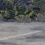
Not only Kilauea volcano with its multiple explosive, rock-throwing and effusive, lava-flowing eruptions are causes for change in the landscape. Significant change and damage potential comes from strong earthquakes, like the 1983 M6.6 Kaoiki Earthquake, that occurred only some 15 miles from here on the southwestern flank of Mauna Loa. It was strong enough to yet alter the landscape around Kilauea caldera, change once more the path of Crater Rim Drive and create this huge landslide that you are seeing in front of you. These are massive boulders that have fallen down all along Steam Vents to Earthquake Trail section of Kilauea caldera! Multiple large earthquakes have shaken Hawai’i in the past, the last strong one in 2006, causing damage in the northern part of the island especially. A secondary effect of earthquakes are tsunami, destructive waves that have led to massive destruction on the Hawai’ian islands before. If you have been to Hilo, you may have visited the Pacific Tsunami Museum, commemorating especially the destructive 1946 tsunami generated by a strong earthquake in the Aleutian island arc. The 2011 Tohuku, Japan, Earthquake and tsunami caused damage in some of our other national parks here on the Big island on the west coast near Kailua-Kona.

Landslide and rockfall into Kilauea Caldera, Halema'uma'u Trail, Hawai'i Volcanoes National Park
Stop 6 – The Caldera Floor
Folks, you have made it all the way into the Caldera of an active volcano! This is a good time to rest, have a drink and take your pictures. Let me give you a short overview of what we are witnessing here, and we can take some 5-10 minutes to linger around and enjoy the scenery.
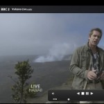
For the ongoing eruption inside Halema’uma’u crater, we are not allowed to venture closer to the crater. You may have noticed that I seem to use crater and caldera interchangeably, and the difference is really just the size. A crater with a diameter of more than 1 mile is usually called a caldera. Their formation process is typically the same – they form through collapse. Had you been visiting Kilauea volcano 500 years ago, you would have observed that it looked like a shield volcano similar to Mauna Loa over there (point out if weather permitting), just smaller. It would have had a very nice summit, from which Lava would be flowing effusively from time to time, adding to the lava layers that build up Kilauea and make it higher successively. Now, something must have happened to the magma reservoir some 500 years ago (BTW, we call molten rock “magma” as long as it is underground, and “lava” once it reaches the surface and is being spewed out or is flowing. We assume that the supply to the upper magma chamber in the volcano was reduced or cut short, and due to the void underneath, the weight of the summit could not be supported, and it collapsed catastrophically – leaving behind this wide caldera here at Kilauea summit, 3 by 2 miles wide. This is important to note – Kilauea did not explode like Mount Saint Helens did in May 1980, for example, which all has to do with the chemical composition of the magma. The less Silica content in the magma, and the less gaseous it is, the more benign and “effusive” the eruption style is going to be. In fact, volcanologists distinguish between “Hawaiian” volcanic eruptions and other styles such as the “Plinian” style named after Mount Vesuvius in Italy that destroyed Pompeji in AD 79.
– Although the Hawaiian eruptions are typically less explosive and dangerous than others (on the scale of the volcano explosivity index, Hawaiian volcanoes would rank in, say, the lower third of potential danger for mankind), don’t be fooled by Pele honua mea, the goddess of fire! Over time, effusive and explosive eruptions change here at Kilauea, and what we are looking at right now is in fact, although not an intense one, still an explosive eruption! Had you been visiting prior to 2008, Halema’uma’u crater would have been a silent witness, not doing much more than look pretty. However, one night in March 2008, there was an explosion that was noticed by the permanent instruments monitoring the volcano, but it was not until the next morning when the scientists from the Hawaiian Volcano Observatory (HVO) of the United States Geological Survey (USGS) got to work that they realized something significant had happened. A big vent (hole) had opened up in the crater, releasing steaming amounts of water vapor and gases, including toxic sulphur dioxide (SO2) of up to 1000 tonnes a day. The scientists immediately took to their reconnaissance vehicle and drove to a portion of what is now the closed section of Crater Rim Drive. As soon as they hit the plume, their visibility reduced to zero and they needed to inch slowly forward. They crept ahead, and CRUNCH – BUMP – CRASH – oh no, must have driven off the road! Well, in fact they had not, but the crunching came from rocks and cinder ejected in the explosion. Although small when compared to prior explosive events at Kilauea like the 1790 and earlier eruptions, this should act as a small reminder that Kilauea can be explosive, quite often so actually!
– Right here, we are standing on witnesses of other landscape changing events. This is an effusive event from 1974, so the lavas that we can see here are barely 40 years old, nothing compared to the geologic ages with which our earth is usually explained. So when geologists are typically talking millions and hundres of millions of years, you start to understand how exciting it must be for a scientist to see how new earth is born as we speak!
– Let’s linger on here for a few more minutes to enjoy the spectacular scenery before we have to do some hard business of the day – climbing back up the 400 ft elevation change that we dropped from where we started the hike right there (point out directions).

Lehua flower on an Ohia tree that has pioneered out onto the lava of the 1974 flow inside Kilauea Caldera, Hawai'i Volcanoes National Park

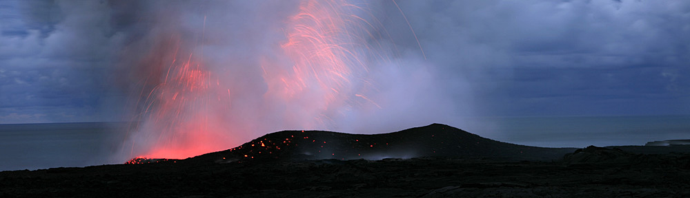
Halema'uma'u Crater puts on a show with its night glow - expression of the ongoing eruption at the summit since 2008, Hawai'i Volcanoes National Park, Big Island, USA
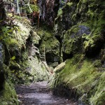
Stop 7: Hapu’u Pulu vs Hapu’u Ii
We have now climbed back into the rainforest. Here is a rather rare species of Hapu’u ferns, it is called Hapu’u Ii. It has the red and black dots, almost like thorns, on the fern stems. Compared to its much softer sibling, the Pulu, it is considered the more masculine, dominant form. If you put the two next to each other, it is very much like Husband and Wife, but in reality these are two completely separate species that would not interbreed.
")
The rare Hapu'u Ii fern is found just beyond the intersection with the Kilauea Iki Trail, Hawai'i Volcanoes National Park
")
The rare Hapu'u Ii fern is found just beyond the intersection with the Kilauea Iki Trail, Hawai'i Volcanoes National Park
Stop 8: Sensory experiences
At this point in time, let’s take another quick rest. In fact, we have calmed down so far now from our steep climb back up that our pulse is back to normal and we should use some of our other senses to experience Hawaii Volcanoes National Pakr. Up to this point, mostly we have used our eyes to see and our ears to hear my talking, but what I really would like you to have is a full experience of the park. So let’s take a moment to spread out a little and get to touch, smell and hear the Park. You are welcome to find and touch some of the velvety fuzz of the Hapu’u fern, find some invasive species, smell the sweet ginger smell or close your eyes and listen to the native birds up above our heads. Take your time!
Stop 9: Overlook of Kilauea Iki crater, Pu’u Pua’i red cinder hill and view of the main eruption vent from the 1959 eruption. This was one of the most fascinating eruptions that lasted only for a short time but drew visitors in flocks so large that cars were queuing and causing traffic jams all the way up from Hilo and people arriving in cars had to be given 10 minute tickets to get the traffic flowing again. Some people would hike up from Mountain View or similar and as pedestrians got somewhat unlimited access to witness the show that started, as I said before quite typical, with a fissure eruption and then poured lava fountains up to 1900 feet high. The fallout, ash and cinder, in the predominant wind direction created Pu’u Pua’i across and led to the rerouting of Crater Rim Drive permanently.

View into Kilauea Iki Crater
Stop 10: Old Crater Rim Drive
As we are nearing the end of our hike today, I just wanted to briefly summarize what changescapes we have walked across today. We started with the topographic marker that was almost fully overgrown now – forests change the look and feel of our landscapes in general.
In particular, we have looked at the native and the invasive species and how they change the forest itself.
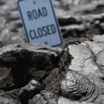
We have talked extensively about the prime topic that you have come for today – Kilauea Volcano, its eruptions and how they change the landscape. We have come to another section here that has changed the very form and layout of Crater Rim Drive itself: In 1959, the Kilauea Iki area got devastated in what is now “Devastation Trail” and permanently rerouted this section. In 2008, the ongoing explosive eruption in Halema’uma’u started, which you know is still ongoing, and that forced the closure of the southwestern portion of Crater Rim Drive – a very small section of which, out to Keanakako’i Crater, has been recently reopened for foot traffic only – so you see we can hardly keep up with updating and redrawing the handout maps.
Now at this very point here, Crater Rim Drive got changed for another, third time. This was in 1983, and it was due to this (hold up Earthquake pictures) – a large, Magnitude 6.6 earthquake just about 15 miles from here on the flanks of Mauna Loa, the Kaoiki EQ, that caused the massive landslides we have seen as we descended into the Caldera, and also toppled this part of crater rim drive. It is the very same spot that you are standing on right now!

The 1983 Kaoiki Earthquake caused the collapse and rerouting of Crater Rim Drive

View of Crater Rim Trail after the Earthquake as seen today - can you imagine how much has changed already in that short time?


")
")