Day 49: Summit Hike: Check

Yesterday I completed my first summit hike, and it was really nice. Now you start to understand why rangers actually want to get out and do hikes rather than talks – in comparison, the “How it all started” speech is small and not so interesting compared to actually going out and touch things and explain the situation real-time. Picking up Himalayan Ginger, smelling the flowers, telling the story of the lovers of Ohia and Lehua right underneath the tree and standing at Kilauea Overlook and pointing right into the crater is really different than just talking about it, even if you are only standing few hundred yards away from it.

So I am glad that it all went well, I had about 20 people tagging along and it took me about an hour to complete the summit walk, so I probably should work a little bit on cutting down the things I talk about to stay within an hour for sure.

Ranger Shyla took us three volunteers out to the Lava Rock Cafe in Volcano village that night, too, which was a particularly nice treat and we really enjoyed it. It actually got quite late and I am on the early shift today… lots of French and Germans in the visitor center, too, so I get to practice the languages at the same time!

Day 45: Day 2 of the Festival at “PuHo”

Sunday started with the same boxes with the same content to be carried – oh I forgot, and of course the mats, only this time they were much dirtier than the day before 😉

A few highlights obviously were left for the last day of the festival, including the food tasting, which I anticipated would draw the crowds and get long lines, but I made sure I got my samples, too! I especially liked the coconut pudding, and the poi with the pig wasn’t bad, either. I was surprised how good “pure” sugarcane actually tastes (just suck the sugar out until you are left with a little bit of wood that you spit out).

This was the day I was busy most of the morning doing my Kapa (see picture of the day) and taking pictures along with it. Then came the lines for the food tasting and our prepared lunch itself and then pretty much every thing got very busy and nervous for the “Grand Finale”, the Hukilau, the traditional community fishing demonstration. I am also trying to upload a small video excerpt of that if our bandwidth of the internet connection permits…

I had wished to get a Lomilomi treatment, but there were only two treatment tables and of course the regular guests had priority, and sign up for it they did! So that remains to be a payable activity I probably will pursue later once off from HAVO, but clearly there was a lot of learning and fun in addition to the free samples and free gifts or material we were given! I am looking forward to the festival here at Hawai’i Volcanoes and am wondering if the same people will be coming as “practitioners”.

Day 43/44: Festival at Puuhonua o Honaunau

We International Volunteers hadn’t really known what we had gotten ourselves into when agreeing (had I really?) that we would help out at the “PuHo” cultural festival when asked by email some months ago. I guess by that time I didn’t know where the Historical Park of Pu’uhonua o Honaunau was located (2.5 hours away from HAVO), nor what our task (unloader/loader and runners) would be. In addition, we were told to stay in a dorm house with other volunteers helping out, and you know how light my sleep is…

Well, we got a list of what to bring to the bunkhouse (pretty much anything, from linen, towels, pillows and blankets to cutlery and pots and pans, though we decided to ignore the latter and to take the chance of eating out in Kailua-Kona) a few days prior to leaving, and packed up the car Friday at noon for the long drive down. I had the early shift at the KVC Visitor Center that day so worked from 0730 to 1200, got the car filled up and ready and picked up the other guys. Ed was leading the way in his own car (he would stay at a hotel, smart choice…), and before 3 pm we were greeted by the staff at PuHo park and given some basic instructions on what to expect during the next two days. The program looked pretty spectacular, so looking forward to meeting all the local practitioners and learning a lot about Hawaiian culture.

The dorm, however, proved really gross. First of all, we had no keys so dependent on everyone else. There’s termite piles on the floor and the beds, and literally the male dorm room is four wood planks with no windows but rather just mosquito nets and some blinds. So, out of here, packed the towels and snorkels and off to Kailua. I took the other two downtown for some “Loco Moco” Hawaiian fast food first, then to Old Airport Beach, where we stayed until sunset. The location is great, and the waves are too, but unfortunately the entry is very rocky and not so good for swimming until your further out – I cut open my feet pretty good, so limping again…

Panorama of old airport beach park, kailua-kona, hawaii

Panorama of old airport beach park, kailua-kona, hawaii


Volcanic rock at Old Airport Beach, Kailua-Kona, Hawaii

Volcanic rock at Old Airport Beach, Kailua-Kona, Hawaii

Sunset, Old Airport Beach, Hawaii

Sunset, Old Airport Beach, Hawaii

Here’s the thing then, after the food that we really enjoyed, back at the dorm by about 9.30 pm – and everyone was fast asleep already. Worse still, someone had thought that my case with the linen and my pillows and stuff was “self service” and used that for his own bed and in the same movement just shoved all the termite piles from his bed back onto mine. I don’t think that was good behavior and display of HAVO employees (which apparently all were), and made me really angry to clean everything up and improvise in the dark. Well, from us three I was not the only one sleeping very badly and we really contemplated the idea of moving to a hotel (the other guys got up as early as 4.30 am!).

The other morning was really nice and the setting of PuHo is pure paradise – beach, grassland, pond, turtles and fish, an array of palms and the breeze always coming in lightly to help cut down on the heat. By 7 am, we were carrying mats to the 43 (!) activities foreseen for the festival and helped getting everything started. By 8, most of the practitioners for Kapa, Hula, Lomilomi, ‘ohe hano ihu and so many more. I really liked the Canoe race but couldn’t get into the water with my feet, but worked on my nose flute during the time we got to explore the festival ourselves between the jobs we were needed (it was not much really, just getting the stuff up and down in the morning and afternoon). I tried Kava (probably my first drug experience ever, if that qualifies), and contrary to many others I actually liked it somehow.

Panorama of Canoe at PuHo

Panorama of Canoe at PuHo, Kailua-Kona, Hawaii

Beautiful gourd, PuHo festival

Beautiful gourd, PuHo festival

Ti Leaf sandal manufacturing

Ti Leaf sandal manufacturing, PuHo festival

Poi pounding from Taro

Poi pounding from Taro, PuHo festival

There was so much to check out, it was really amazing. Some people mentioned – and I agree to a certain extent – that some of the Hawaiian tradition is not really authentic and got reinvented only after the Hawaiians discovered themselves again. It is true, for a while Hawaiian tradition was not recognized very well amongst themselves and everything should be as American as possible, but still it has a very good feel to it, and definitely it felt very right in this so magic place here. While tired and hot from the sun and the moisture and the heat, I enjoyed all of it and learnt to many new things. I am practicing my bamboo nose flute play, especially, and still think I should get that third hole in it – I will talk to the ‘ohe hano ihu players here at HAVO – the festival is coming up in two weeks!

In my next blog, I will continue with the second full day (Sunday) of the festival, what the food tasting was like and I performed at Kapa making…

Day 40: Walk with me the summit loop – a story of hope

1. Introduction, welcome and start of walk from flag pole
Aloha and welcome to my summit walk here at Hawai‘i Volcanoes National Park. My name is Michael, and I am a volunteer ranger at the park. Our walk looping around the summit of Kilauea Volcano will take you into the rainforest and to beautiful outlooks across the Caldera. During the next 45 minutes or so, I will give you an overview over the richness and diversity of this landscape and how the Hawai‘ians made best use for it. As I am a geologist by training, I will also cover the volcano and its history. So if you are ready, then let‘s go.

Meet the park ranger - start

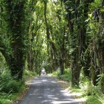
Meet the park ranger - start of the Kilauea summit walk

Starting the summit walk

Starting the summit walk

2. The richness of the rainforest
Our first stop is here just across the road at this beautiful Hapu‘u fern (Cibotium menziesii). Look at this giant nurse log at the bottom – that‘s what is supporting the Hapu‘u. In fact, Hawaiians also called these ferns the walking ferns – once the parents have grown too high and they can‘t support their own weight any more, they will crash to the ground and nurture their „keiki“, their children: The cycle repeats as new sprouts will shoot from the nurse tree that has fallen, and the new tree fern will grow several feet away from the former position.
I talked about the richness of the rainforest and how Hawai‘ians used all that was produced from it at my introduction. Let‘s give this a closer look. We could also consider that we are currently standing inside the native Hawaiian „Walmart“ – most of what the people needed was either harvested from the forest or came from the ocean. You may find out that everything that was important for the people carried a name, while the rest did not. Everything had its place and meaning here on the islands, as resources were scarce and work hard to make a living. Nothing that supported the island life was wasted – recycling and using up everything from roots to bark to wood to fruit or ferns or flowers was the standard although the word „sustainability“ did not exist obviously at that time – neat, isn‘t it?!

Hapu'u tree fern - summit walk

Hapu'u tree fern - summit walk

Where did all this come from, here to this island more than 2‘000 miles from pretty much anywhere in the middle of the Pacific Ocean? The solution lies behind the three „Ws“, as we like to call it – the plants that we see here have traveled with the help of these three Ws and have evolved and adapted here to become individual new species found nowhere else on earth. So what are these three?
– Waves, Wind and Wings.

If we turn around here, we will encounter one of the most abundant tree on the big island. It is the one that has these interesting leaves that you find as sicles – or shall we call it half moons? – here on the ground. Does anyone know what it is? It is the Koa tree (Acacia Koa) Koa means „warrior“ or „brave“ in Hawaiian, and it has some of the hardest wood you will find anywhere on the world. This was the tree used to produce canoes, and it was a long and enduring procedure to get the right tree selected, to get it cut down and hollowed out partially. This was done in the forest, sometimes several thousand feet up in elevation, not at the coast. This has an obvious advantage: A hollowed out tree is much easier to carry down to the ocean, and the work was probably also more agreeable in the shady forest. Selecting the right tree was a big ceremony. You had to ask for permission before any tree could be selected and cut. Also, it was a good sign if the Elepaio bird was not found near the tree. The saying goes that the Elepaio bird would be talking to the canoe builders: If it was sitting and singing on the Koa tree for a longer period of time, that meant „This is my tree. You cannot have it“. If the bird flew away, it meant to say „this is your tree, you can have it to build a nice canoe“. Scientists find that Elepaio birds can get to the inner part of the tree and feed if the inner part of the tree is rotten, so this is where the Elepaio indication comes from. If you ever have the chance to visit one of our other National Park sites here on the big island down at the coast toward Kona, Pu‘uhonua o Honaunau, the place where the Ali‘i resided and the place of refuge, you should go and see Charlie. He keeps the tradition of canoe buliding alive and is very knowledgeable about the Koas and canoes.
By the way, talking about finding trees around the world – this one here is „endemic“ to Hawai‘i, which means that it is nowhere else found but on some of our islands. There are four words we want to distinguish when we talk about encountering plants or animals:
• Endemic, or found just in a specific place as I just explained.
• Native, or typical in one place, but also found in other places.
• Introduced, or species originally foreign to a certain place such as Hawai‘i. Once established in the new place, it did not have too negative consquences.
• Invasive, or originally foreign to a certain place but introduced with detrimental consequences. We will be talking about invasive species in a minute.

3. The invasions and dangers to the native forest
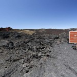
With European contact and with more denser settlement on the Hawai‘ian islands, many things changed. Amongst other, new species, both flora and fauna, got introduced. Here, we have stopped at the second most problematic species of plant that was about to take over and push aside the lush native and endemic rain forest plants. Do you know what it is?
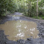
It is actually one of the most abundant plants now in parts of the park, like along this trail or also along the Halema‘uma‘u crater trail which we will encounter at the end of our walk. It is called „Kahili Ginger“ by the Hawaiians because of the resemblance to the Hawaiian Kahili, the symbols of Hawaiian Royalty, but I really don‘t like this expression, given to a plant which has nothing to do here: It is Himalayan Yellow Ginger (Hedychium gardnerianum). It is considered as one of the worst alien species, and do you know why it was planted here, what its purpose was? Honestly, it does not have a purpose at all, really. It is purely ornamental and was planted by people in their gardens to look and smell good. In fact, the yellow flowers are quite nice, so is the scent, if you want to take a sniff. The problem, however, is that it does not have any natural predators here, and it can grow really fast and will outgrow and push aside the native flora. The park has invested a lot of money and effort to get it out again, but as you can see, this works only in patches so far and needs to be done right – it is a combination of aggressive herbicides specifically prepared for the ginger and the right weeding technique – it needs both in the right mixture to get it out.

Kahili Ginger - Himalayan Yellow Ginger

Kahili Ginger - Himalayan Yellow Ginger

Detail of raindrops on Kahili ginger leaf

Detail of raindrops on Kahili ginger leaf

Detail of Kahili Ginger flower

Detail of Kahili Ginger flower

A good contrast between how native and how invasive species work can be seen here. We discussed the ginger – it grows fast, has large spreading roots and does not like to share, it wants to have it all. Conversely, look at this Koa tree. Do you notice this small plant here, growing out of the stem fork? It is Ohia Lehua, another very important endemic tree that we will talk about at the end of our summit tour. This much for the moment: Koa and Ohia like to share, they don‘t destroy each other but are a very fine example indeed of symbiotic living, of living together.

Symbiotic living: Koa and Ohia

Symbiotic living: Koa and Ohia

4. Looking at the single worst invasive plant
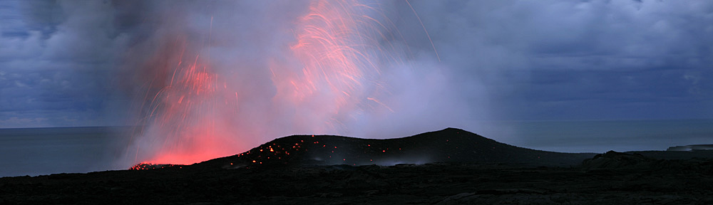
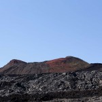
We have reached a wonderful outlook across the Kilauea caldera towards Halema‘uma‘u, the ongoing active eruption since 2008. But before we turn to the volcano and a little bit about its creation and current activity levels, I need to follow up on what I said before: Kahili – erm, NO, Himalayan Yellow Ginger! – I said was the secondmost problematic invasive species. So what is the most problematic one?

Morella faya - Fire tree invasion

Morella faya - Fire tree invasion

We are looking over it right here, right now: It is the so-called fire tree or Morella faya. It has three very bad habits: It produces incredible amounts of seeds that get eaten by birds and dispersed far and wide. Secondly, it binds a lot of fertile nitrogen to its own life cycle and removes nitrogen that would be needed for the other plants that grow here. Thirdly and lastly, it is a very fast and thick grower, outgrowing and dispersing the slow growing native trees. Once Faya has established itself, it will form such a thick canopy that nothing else will be able to grow in its vicinity, really.
If you look down and across the sides of the caldera, you will see that many light green patches are spreading out – all Faya trees. Also, you may notice other patches of dead trees – ongoing efforts to control (eradicate would be the wrong word as the park will probably not be able to achieve this) and reduce the Faya population.

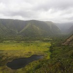
5. The Kilauea caldera
Did you realize that you are already standing inside an active volcano? Yes, in fact ever since you have passed the entrance gate and come by an „opening“ in a small hill, you have entered the outermost rim of the Kilauea („spewing, much spreading“) caldera. Many hundred years back, we don‘t know it exactly, this used to be a fine mountain with a closed top most probably, where periodes of eruptions from the magma supply below made it grow successively.
However, at one point in time the magma reservoir seemed to be lacking resources and was partially drained. The weight of the mountain above could not be supported, and the top of the volcano collapsed into a wide caldera as we see it mostly today at its boundaries – a typical process for volcanoes.
In the 1800s the caldera begann slowly to refill as magma was pushing up again the reservoir underneath. Some of the first Europeans arriving on the island were witnesses of these events. Events of lava outflow followed period of quiescence, but since the first Europeans were standing here, probably at a very similar place than we are now, the caldera has been filled another 600 feet or so. These were mostly non-explosive, so-called effusive events where lava was flowing out in relative peace. But don‘t be fooled: Kilauea is a very active volcano and when Pele, the goddess that is said to live inside the crater, has her temper, there tend to be explosive events, too. In fact, what we are looking at right now is an explosive event. Until 2008, you could drive around the entire Crater Rim Drive and pull up at an outlook into Halema‘uma‘u Crater. But one night in early 2008, Pele came back to live. Scientists in the morning were astonished to find a gaping hole inside Halema‘uma‘u: A vent had opened and blasted away parts of the overlook – some parts just fell into the crater. They promptly started to investigate in their car but couldn‘t see much as they drove along the now closed portion of Crater Rim Drive in thick VOG, volcanic omitted gases. „Crunch, crunch, bump, oh no, we must have driven off the road!!“. In fact, they had not. The car was still lurching along on the road, but driving over ash and small rocks blasted out during the eruption. While this was a small event compared to what geologists know about previous explosive periods at Kilauea, I think this was a good reminder of Kilauea‘s, or shall we say, Pele‘s, nature.
Ever since 2008, Halema‘uma‘u has been active, and this can be seen all around the Caldera not only by the fumes that we can see currently, but also by small ash ejections that can be found especially in the downwind section, but also by Pele‘s hair, these long volcanic fibres that we sometimes even find here – can you find some lying around you? Let‘s be honest: Kilauea is arguably the most active volcano on earth, because since 2008 we have two simultaneously ongoing eruptions, the one here at the summit and one at Pu‘u O‘o vent on the eastern rift zone, that one without real interruptions since 1983!
Here‘s an outlook how to best see lava – come back to Jaggar museum at night. Halema‘uma‘u is supported by a large lava lake some 180 feet below that gaping hole, and while we see only fumes and smoke during daytime because of the bright surrounding light, at night this is what it will turn into – it will be a fascinating reflection of the lava below!

6. Ohia lehua and two stories of hope
We have arrived at the historic Volcano House Hotel. We hope that it will be reopened soon, as this is a truly inspiring place to stay.
Let‘s look at this knobby tree here. It is called Ohia Lehua, and it is linked to Pele‘s temper, the goddess of fire. Let me offer you the following legend: Once upon a time, there was a nice couple, man and woman. He was called Ohia, and she was Lehua. While Lehua was away on business – probably shopping, Ohia was playing the nose flute. The flute is played with the nose, because it is considered the purest breath that mankind has – through our mouths, we can lie and tell bad stories, so this is not pure breath, or „Ha“, as in the word of „Aloha“, in the sense of „presence of the pure breath of life“. Consequently, foreigners that cause problems are called „Haole“, or without pure breath.
So let‘s turn back to Ohia. As he was playing the nose flute, he looked really beautiful and was attracting other females. They asked him for a date and wanted to be with him, but he turned all of them down by confirming that we has promised to Lehua and that the nose flute playing was only for her – she would be returning very soon. So time went by and more girls came by. Ultimately, a very stubborn young lady arrived and told him: You are very beautiful. You will be my boyfriend. Ohia was confused about this aggressive approach and also turned her down by saying that she must be out of her mind telling him what to do and that he already had a beautiful girlfriend.
Of course, this stubborn and aggressive young lady was the personification of Pele, and she was not the person to be turned down. As she was known to have a temper, she turned angry and shouted at him: „How can you dare turning me down! You will be punished for life!“ and to ensure he would never ever be looked at and considered beautiful, she turned him into this ugly tree with peeling bark and unsophisticated green leaves – the Ohia tree.
As Lehua returned, she was astonished to find that her boyfriend was no longer here. She was looking out for him, but nowhere could she find her beloved Ohia. Where had he gone? Something was strange, however – she could feel his presence although he was not here. Ultimately, she discovered that this tree here must be him, and she started to cry. She pledged to the gods that they return him to her, but they all feared the ferocity of Pele and would not do anything to make her anger turn to them. Lehue pledged and whined, and in the end she said that she would be ready to do everything to be together with him, that she would give her live. The gods conferred and admitted that they could do something – as she was willing to give her life, they turned her into the red flowers that you see on the Ohia trees, the Lehue flowers. So Ohia and Lehua were reunited forever, as the tree and the red flowers on it.
The saying goes that noone must ever separate them, otherwise Lehue would start to cry again. So whenever it rains on the windward side of the island, especially here and around Hilo, you may hear people saying: „Who has taken the flower from the tree?!“

So this was my first story of love and hope. The other one is about the invasive and the native species. There is hope that the adaptation and the very intricate mechanisms that the endemic species have developed will help make them survive even the intrustions by the invasive ones. As an example, the Ohia trees here have adapted to living in a volcanic environment. They can open and close their pores through which they breathe according to the toxic conditions of Kilauea. Whenever they sense that too much SO2 and other toxis gases are in the air, they can close their pores and wait for better conditions to breath again – another example of hope.
With this I want to conclude the walk today and thank you for coming out with me. Mahalo and good continuation of your discovery of Hawai‘i Volcanoes National Park.

Ohia Lehua

Ohia Lehua

Day 39: Inside the house

…it feels much cleaner now. I used the morning of my day off to finally use the chemicals and the biologicals to try and get rid of some of the gross stuff. Especially the kitchen corners and the bathroom, including the sink, the tub and the shower curtain, seemed to have never been cleaned in ages – I guess noone of the volunteers really felt responsible for it. As I think I will be the one staying the longest in the house – the others are leaving late July or early August already – I felt really the urge to do something about this and got some of the heavy duty brushes, scrub sponges, bath cleaner and vinegar out. I tell you it was ugly, but now it seems much better (while still not really good, but we are getting there…). Of course, in the pictures below the rooms always look nice with that warm light from the lamp shades, but it feels livable now. By the way, temperature is still a problem, it is sooo cold inside at night. Check the thermometer pic!

Day 38: How, How, How

Today I screwed up a little. I agreed to do two of the “How it all began” talks to get some more practice, and we all took it down in the huddle meeting. We just call it “how” talks and all the activities get entered on a small sheet in the huddle room and then transfered to our ranger activities board, one of the screens at the center and we phone it across to Jaggar Museum so they can display it there, too. For whatever reason I decided to announce my talk over the intercom at the center at 5 to 11, although I then realized I only had scheduled it for 11.30. So of course now I need to go out to do the talk at 11, which attracted a fair crowd that had heard it only via the announcement, and then right away again at 11.30. There were not very many people this time, but those who did come were really interested and questioning. New people walked up as I had the discussions, adding to the questions, and with horror I realized that I hadn’t come back into the center before like 12:20 or so. We should man the front desk quite sensibly over lunch hours, as most people crowd us then and as some of the rangers should get lunch. So it was pretty busy, and of course my third “how” talk of the day started at 1, so I did not get lunch until after that, although this time it was a pretty short talk with little audience – after four days or so, the sun had finally decided to come out, and all the visitors complaining about the bad weather now went off in a hurry to catch some sunlight at the viewing platforms and the hiking trails. So that’s my three “hows” of the day.

I definitely need to work on some more programs, and I guess I will draft the summit hike over my off days so I can try it out next Wednesday or Thursday. Also I was very happy with what I had said so far, many people that I had interactions with I have met again, especially those complaining about the weather and that there was nothing to see – I promised to most of them that there would be a good chance of fair weather for the sunset at the Jaggar Museum, so they could catch the developing night glow. You may have seen the movie of the day from yesterday, as I wanted to check myself, and again we were really lucky. Perfect timing, right around 7 pm the clouds disappeared and it was a spectacular view across Halema’uma’u, Mauna Loa summit drifting above the clouds before the sky turned fully black, and a plentitude of stars including alpha and beta centaury and the southern cross right above the crater.

Everyone was focused on the crater and I told them to look left and right. On the northern flank, Mauna Loa was really just at her best, being this huge, gentle shield volcano jutting up against the clear sky with the sparkling stars, and as I turned my head, clouds were passing on the southern side, offering the perfect screen for a lunar rainbow or moonbow, as you can see in the picture below. Isn’t that awesome? This is featured on the HAVO Facebook page again and is close to another 100 likes.

Day 35: Eppur si muove!

… and yet it moves. I have stolen these famous words from the late Mr. Galilei and put them into a new context, because I want to talk Hawaiian Hot Spot and Mantle Plume theory.

In a nutshell, most volcanic (and seismic) activity occurs around the Pacific “Ring of Fire” due to the most active plate tectonics mechanism there. However, this does not explain the existence of Hawaii, or better, the Emperor-Hawaiian seamount and volcano chain that is very prominent on any bathymetry map. We need the following theories to put the puzzle somewhat together:
– Plate tectonics: As expression of the heat convection / dynamic activity of the earth’s subsurface, plate tectonics is the movement of the various lithospheric plates on the earth surface on the earth mantle, essentially due to convection and plate lifetime (so-called slab subduction pull and divergence push).
– Hot spots as expressions of deep mantle plume activity on the surface. Most prominent hot spots are Iceland, the Capverdes and, of course, Hawai’i-Emperor.
As the current Pacific plate moves across the hotspot in the Mantle (and the Pacific plate moves very fast!), volcanoes and finally volcanic islands above sea surface level “plop” up over time, forming the island and seamount chain that gets gradually older as we move further away from the hot spot. In fact, the oldest of these seamounts may have already been destroyed by the subduction of the Pacific plate near Kamchatka, Russia.

Now, classic theory suggested that Hot Spots are fixed in space and are an absolute orientation point for relative plate motions to each other. That plate motion changes direction every now and then is most clearly visible in the sharp bend between the Emperor seamount chain (northwestern part of the entire topographic ridge in the Pacific) and the Hawai’ian archipelago (the southeastern elements). However, recent studies and much better resolution in understanding plate motions through deep ocean drilling projects and geomagnetic and geochronological science activities on the rocks recovered from there shows that the initial reconstruction of plate motion fails to address all information now available. In fact, recent studies clearly suggest that plate motion change alone cannot explain all the data. Hence the new theory that hot spots are actually moving, too – therefore, and yet the Hawai’ian Hot Spot moves! A very famous discussion for hot spot movements with landmark papers in Science magazine in 2003 and 2009 is well worth checking out.

from http://www.mantleplumes.org/Hawaii.html

This should just serve as a brief explanation. Whoever is interested, here’s my draft preparation of my first “How” talk that I may be given anytime soon this week, yay!

1. Introduction, welcome and explanation of “Journey in Time and Space” theme.
Aloha, and welcome to Hawai’i Volcanoes National Park. My name is Michael, and I am a volunteer ranger here at the park. Thanks for joining my talk today. I assume from what I have heard that you all have traveled far, more or less, and I also would like to take you onto a journey now. This is going to be a journey back in time, to the creation of the Hawai’ian Islands, and how it all began. As we move along, I will tell you about the basic principles that made the formation of the islands possible, how the volcanoes have developed on the island chain, and how they shape our landscape here and our everyday life. We will then advance slowly in time and space to arrive at the eight main Hawai’ian islands as we know them today, and make our way across the Big Island of Hawai’i here (show relief map) to arrive at the present time and space, looking at the ongoing eruption of Kilauea. So are you ready to be beamed back in time? Yes?? So let’s go (bzzzzz)!

2. Emperor seamounts and discovery of geodynamics principles:
2.1 Journey to Kamchatka:
So here we are, some 85 million years back to were we just were. Is that not an incredibly long time, really hard to grasp? I mean, everyone has her or his own notion of time, but this is a time span just difficult to imagine. Now, for the processes that shape our earth, this is the sloooow pace that we should be taking to understand them a little bit better. But let’s get oriented first. We are standing right here (Show Kamchatka peninsula), and here it is where the formation of the Hawai’ian island chain actually begins. Now wait, where are we in fact? This is Russia, so this cannot be right?! Don’t worry, we have come to the right place. We are 3’800 miles from our current position of the active volcanoes on Hawai’i, and we are looking at a chain of underwater hills or “seamounts” that started forming about 85 million years ago. This ridge in the middle of the ocean is called the Emperor volcanic chain, and it is the foundation of the entire Hawai’ian islands. I said volcanic: So let’s look at how volcanoes form before we come back to this place on our journey (cliffhanger).
2.2 The Pacific ring of fire:
Here’s a map of the surface of our earth, and it shows the activity recordings of volcanoes in red and earthquakes in blue. Let’s think about this for a minute – would you like to make any comments what you notice? (Interaction with the audience, open phrased question with many possible observations. Goal: Guide them to discovery of plate tectonics and volcanism)
You have observed that most of the dynamic forces on earth are concentrated around the basin of the Pacific Ocean, that’s right! Scientists call this the “Ring of Fire”, as most destructive earthquakes and large volcanic activity is found around that Pacific Rim. You also noticed that more volcanic activity and earthquakes are found in these ridges in the ocean here. They are correlated to each other: At this one (show divergent one), new crust is being formed through volcanic activity and pushed to either side. We call this a constructive or divergent plate boundary, because new earth crust is constructed and moved to either side of its formation. This is one part that drives the overall dynamic cycle I was talking about. The other one is found along the Pacific Ring of Fire we just spoke about. Here, the plates collide with each other and are partially destroyed again. The heavier plate is crunched underneath the lighter one, a mechanism we call subduction. So the heavier oceanic plate is subducted underneath the ligther continental one. Unimaginable forces so strong that entire mountain chains are formed and destructive energy built up to be released in powerful earthqukes. And of course, as you can see, this creates a lot of volcanic activity. The entire concept of earth crust moving around in distinct individual pieces, I am sure you have heard it before, is called plate tectonics.

2.3: Convection and hot spots:
Now there is one missing piece in the puzzle that we need yet to discover: Have you got an idea of where all this energy is coming from that drives this crazy boat race on our earth surface that we call plate tectonics? Correct, it is thermal energy – or simply put, heat. This heat is coming from the earth’s interior and is composed of partially radioactive energy, but mostly from the cooling of the very hot interior of the earth. As you know when you let a snowball melt in your hands or your Iced Coffee sit in the hot car, temperature differences want to be equalized. This makes the snowball melt and our hands go a little colder. The same happens inside the earth – warm stuff cools out a little and may get in contact with colder material that is warmed up a little. This works pretty much like your stove at home when you boil water. The boiling takes not place equally in all places, but certain places tend to be hotter than other ones around it, and they will drive a dynamic principle that we call convection: Warm stuff moves up and can take some cooler stuff down in a convective circle. This is exactly what drives our plates on the surface of the earth around.
Now please help me out a little (interaction after the heavy stuff), as I am a little bit lost. We said that volcanism and plate tectonics occurr mostly around the Pacific Ring of Fire yet we are in the middle of it, with no contintents anywhere to be seen. How can that be?! Well, some of the heat packages that we just discovered in our convection principle may occurr in very isolated pockets, where hot magma (that is, molten rock) from deep of the interior of the earth suddenly makes its way up towards the surface because it is so hot and light. It will rise all the way up to the surface of the ocean floor, melt up the surrounding rock and – that’s right, form a volcano! We call this location on Earth a “Hot spot” – there are a few of them around on our world, but the most famous is of course, Hawai’i.

3. Integration of principles and self-discovery for audience

With these basic principles in mind, let’s focus back on the Emperor seamounts (repeat for better memory) where we had our first sightseeing stop on our 85 ma long journey. With the two principles of the Hot Spot and Plate Tectonics in mind, we can now discover how the chain of volcanoes formed in the middle of the ocean. 85 ma ago, the Pacific Plate was slowly moving northnorthwest over the hot spot with a speed of several inches a year – this is as much as your fingernails typically grow, another natural process although we not always like that one, right?!. Where the hot spot penetrated the sea floor, a volcano was slowly being built by eruptions pretty much as we see it today. Given enough time and eruptive activity, the island may well have looked similar to the one we are currently standing on. As the plate moved across the hot spot and further away, volcanic activity ebbed and left a volcanic islands subject to the forces on surface – the weather is mostly responsible for wearing the mountains down into beautiful valleys, steep gulches and sandy beaches.
In addition, further away from this first island on the chain, the hotspot was still active and had produced a second, then a third etc. island very much by the same principles that we just uncovered. On this map, we can basically jump our way ahead step by step over these volcanic seamounts, now eroded below sea level. Every jump signifies several million years forward in time. Let’s move on to about 43 ma, which will take us about here. We have progressed across 45 of the Emperor seamounts. Now here’s a noteable change that we should probably try to understand, as everything is here for a reason – what may this have been? (Depending on type of audience, explain change in plate tectonic direction and also about the assumptions of the non-stationarity of the “wiggling” hot spot or leave the latter out if audience not interested or too young etc.).

4. The Hawai’ian island chain
So we have come half way in time. About 84 volcanoes are left for us to visit. Shall we stop at every one of them? That may take a little too long and it may be too hard to learn all the names. We are here for the fun of it, and we have enough information to understand the creation of Hawai’i, so let’s put the science away and discover Hawai’i as we still see it today. Our clock has moved forward to about 5 ma – the formation of Kaua’i, the oldest of the remaining islands today. You may notice this when visiting Kaua’i, as the shoreline and the mountains are very steep and rugged, erosion has been able to play around for a longer time compared to the other islands. In sequence, the next islands are Ni’ihau and O’ahu, all a few ma old. A small gap in time and space follows, as you can see on the map, before we reach Moloka’i with some 2 ma, Lana’i, Maui, Kaho’olawe, and finally, the big island (focus on the relief map now).

5. The volcanoes of the Big Island
We have started our last million years in our journey in time and space. We have arrived on this island, at the very northernmost tip, and all that is south of that area would still be underneath the sea level. We are looking at the oldest volcano of the Big Island, and it is about 700’000 years ago when activity started here. It’s name is Kohala, and it was active for a very long time, but as you can see by the steep terrain, erosion was very active, too. Some of the most secluded, beautiful steep valleys are found here, such as Waipi’o valley (show on map).
Next in row is Hualalai, a volcano that like the rest to follow, is still considered potentially active by our geologists out there from the USGS volcano observatory. It is likely to erupt in the near future again, and some of you may actually be staying in an area where lava flows from Hualalai are prominent (show resort areas of north west coast).
We now come to the volcanoes that you certainly will have heard about or even have come to discover during your own journey here: Mauna Kea, the highest mountain of the Hawai’ian islands at 13’796 ft ASL. It’s name means the “white mountain” for two reasons – snow can fall any time throughout the year in the summit area, and it was heavily glaciated during colder periods in our climate. This would have been some ka to 10ka ago. Then we have, to the south, Mauna Loa, the long mountain
Are you exhausted from this long journey?? We have been 6’000 miles in space and over 85 ma in time, and we have arrived, back here, at Kilauea, arguably the most active volcano on earth, with two eruptive eruptions right at this time – from the summit at Halema’uma’u crater and from its eastern rift zone at Pu’u O’o crater, ongoing since 1983, which also is a world record on its own. We are back in the present time, and here are some fascinating impressions of what you can discover during your real, not fictitious journey, through Hawai’ Volcanoes National Park.

6. Outlook and End:
Now that we have made it full circle back to the visitors center at the summit of Kilauea here (show on map), I want to offer you a brief outlook into the future. I have alluded to it before: Time and space are invariably connected to each other. In fact, time is considered often to be the fourth dimension besides the three dimensions that we have in space (show with arm movements). So lets follow the line of volcanoes here (show on chart), and we will arrive in the middle of the ocean here. This is the place where the next Hawai’ian island is currently being born – it is not quite yet an island. The name is Lo’ihi, and it is currently a seamount – an underwater volcano. Lo’ihi means “Far in time” in Hawai’ian, and if the current eruptive activity keeps on going at its present state, it will be probably another 600’000 years before it will surface as an island above the sea water line – but it has already progressed 13’000 ft up from the sea bottom surrounding it! With that, I would like to thank you for coming over and listening to me, and I’d like to send you out to your own journey, discovering the beauty of the park and its ever changing landscape. As you now know: A journey in time and space!

Day 33: Sun and Lava – climbing Mauna Loa

Sun and Lava – this describes the trail quite well, as there ain’t much more to see. Perhaps I misjudge the beauty and power of Mauna Loa at the moment because I feel so miserable, but the entire trail was just lava in all its forms – ropy Pahoehoe falling apart as you step on it, jagged small pieces of A’a moving all the time as you step on it (and you sure don’t want to slip and fall there), all sorts of ash and small pieces of fallout that makes you sink in – in fact, it wasn’t a trail at all. It was rather “trail markings and you make up the trail yourself as you go along”, with Ahu rock piles (or cairns) on the way. A word of caution on the Ahus, by the way: Neither make them yourself (in Hawai’i, it is not considered a good blessing for yourself) nor destroy them. They serve as trail markings in a land of lava where no other orientation points are around, and it also brings huge difficulty to the volcanologists as they try to date and record lava rocks that have been “anthropogetically moved”.

I have taken what is considered the “easy route” up to Mauna Loa – drive to the Mauna Loa Observatory and hike the remaining 2500 feet or so to the summit. But pardon me, it is still a 13600 ft / 4167 m high mountain – in fact, my first 4000+ m ASL mountain that I “climbed”, although not from the bottom, of course. It took me six hours round trip, my backpack was too heavy, I was relatively short on time because I had to return the rental car today (yup, days off over, back to work!) and needed help doing so, which meant doing the trip to Hilo twice. Walking over uncharted lava seems to activate completely different parts of your feet – I have never had blisters in these hiking boots of mine, and boy do I have blisters in areas I would not have imagined one could develop such blisters. I guess I will have to walk awkwardly for a little why and stay out of the water. But I hope soon the pain is forgotten and the memories of having climbed Mauna Loa will persist. Find the photo gallery below.

ADDENDUM: After reading some journals with other people’s experience of hiking Mauna Loa, like this one, it seems I didn’t fare too bad after all?!

Day 31-32: Getting around a little

I haven’t written a longer text sequence, and I think i owe you an update. However, the daily photo and video section may have given you an idea of what’s been going on.

So I currently have three days off in a row and I thought I’d take the occasion to rent a car and get out of the bunkhouse and the park a little. This sounds easier than it really is, though, as every somewhat businesslike activity (such as renting a car) requires a 50 km ride down to Hilo to get anything accomplished at all. Getting down was somewhat easy as Chuck (the volunteer from the previous 3 months term) was leaving anyway and I could just jump on the ride that was offered to him. However, getting the rental car back on Tuesday was not such an easy feat, and involved another driver. Because I am currently the only one with the DOI government defensive driving certificate, this means I had to register whoever was accompanying me so he could drive the rental car back down, while I was driving the government vehicle. And as always, Andrej needed to get some shopping done, so suddenly nice Melissa driving Chuck down to see him off was confronted with a really full carload…

Another thing that struck me was that I needed to present the rental voucher in print – I had just booked online three days earlier and was glad to have received the voucher per email. I was told that this was not good, as it was not an “e-voucher”, and needed to either print or mail it to the lady at the counter of the rental agency. Sorry that I don’t carry a printer around with me all the time, and I also wanted to avoid the Wi-Fi fee of 6.95 at the airport – finally the rental lady agreed that I could take the car as long as I drove it to Starbucks first (free Wi-Fi) to send the voucher immediately across, which I did.

Finally, mobile again. I went down Chain of Craters road inside the park to discover whether anything was going on at the active lava flow, but it was really pitch black – not a thing to see. Disappointed of the wasted hour, I called it a day (I am reporting Day 30).

So, Day 31 started with a ride down to Pahoa and the beaches at Kumukahi Cape & Lighthouse – the place we went to visit with Jay last weekend already, but I thought I’d give it another try during the day to take a swim in the so-called Champagne Pools (bubbling thermal water mixes with the salt water of the ocean that is blocked off partially by a rocky beach, really an interesting swim with warm water and little salt content) and try out the Lava path myself. Poor Jeep (and don’t tell the rental agency, I am sure I am in hell already for taking the car to all the roads and paths that are off-limit by the contract). I then discovered the thick and immensely green tree tunnels of “Mango Grove” and the Nanawele sand hills, littoral volcanic cones that formed during intense explosive ocean entry of lava flows. There even is a sea arch there! Not much after that, spending the hottest and least photographic time of the day at Starbucks – the day has flown by, also reading a chapter or two of our “Interpretive Bible” in the shade. Took in Rainbow Falls in Hilo at the end of the day, also trying to do an after dark shot of the waterfalls, but not too successful. And not to forget: The return drive to the park is always 30+ minutes and 1200+ meters in elevation gain!

Day 32: Off to Pahoa again – I had left my beach sandals at the beach – not that the name of the shoes would suggest where they belong. Luckily, they had stayed put at the exact same place in that secluded parking lot at Nanawale sand hills, really lucky me! I took a leisurely pace up the cost along the Belt Highway up to Waipio Valley and ventured down in the car. It does take a bit of courage, especially if you think that once you are down you have no choice but must make it back up – I usually prefer to drive a critical path up so I can turnaround if it does not work out. You may imagine that I made it back up somewhat safely as I am writing these lines, but there were a few moments I did not feel so comfortable. And during all my stay back down inside Waipio there was this nagging question whether I would make it back up easily or not. Alas, I was down at the beach, parked the car in the sand and got going. The stream crossing with my big photo backpack was really tricky and I couldn’t afford to slip, so the tripod came in handy as an additional stabilizer for myself. Surf was really way up, almost nothing left of the famous black sand at the beach. Hiking was slow in my sandals across the surf as I made my way to the other side – I wanted to try the switchbacks up the trail to at least half the height so I had that perfect venture point into Waipio Valley itself. And what a magnificent sight it is (also check the daily photo!). The gallery below gives some impressions including the car and the dirt road. And there even is this commercial van driver that really must be crazy, driving a 25% grade up with the rear doors open for the fun of it! Fingers crossed that the rental car agency does not jump up and down when I return the car, I put so much effort in cleaning it here at the car wash station of the Law Enforcement at the park!