… and yet it moves. I have stolen these famous words from the late Mr. Galilei and put them into a new context, because I want to talk Hawaiian Hot Spot and Mantle Plume theory.
In a nutshell, most volcanic (and seismic) activity occurs around the Pacific “Ring of Fire” due to the most active plate tectonics mechanism there. However, this does not explain the existence of Hawaii, or better, the Emperor-Hawaiian seamount and volcano chain that is very prominent on any bathymetry map. We need the following theories to put the puzzle somewhat together:
– Plate tectonics: As expression of the heat convection / dynamic activity of the earth’s subsurface, plate tectonics is the movement of the various lithospheric plates on the earth surface on the earth mantle, essentially due to convection and plate lifetime (so-called slab subduction pull and divergence push).
– Hot spots as expressions of deep mantle plume activity on the surface. Most prominent hot spots are Iceland, the Capverdes and, of course, Hawai’i-Emperor.
As the current Pacific plate moves across the hotspot in the Mantle (and the Pacific plate moves very fast!), volcanoes and finally volcanic islands above sea surface level “plop” up over time, forming the island and seamount chain that gets gradually older as we move further away from the hot spot. In fact, the oldest of these seamounts may have already been destroyed by the subduction of the Pacific plate near Kamchatka, Russia.
Now, classic theory suggested that Hot Spots are fixed in space and are an absolute orientation point for relative plate motions to each other. That plate motion changes direction every now and then is most clearly visible in the sharp bend between the Emperor seamount chain (northwestern part of the entire topographic ridge in the Pacific) and the Hawai’ian archipelago (the southeastern elements). However, recent studies and much better resolution in understanding plate motions through deep ocean drilling projects and geomagnetic and geochronological science activities on the rocks recovered from there shows that the initial reconstruction of plate motion fails to address all information now available. In fact, recent studies clearly suggest that plate motion change alone cannot explain all the data. Hence the new theory that hot spots are actually moving, too – therefore, and yet the Hawai’ian Hot Spot moves! A very famous discussion for hot spot movements with landmark papers in Science magazine in 2003 and 2009 is well worth checking out.

from http://www.mantleplumes.org/Hawaii.html
This should just serve as a brief explanation. Whoever is interested, here’s my draft preparation of my first “How” talk that I may be given anytime soon this week, yay!
1. Introduction, welcome and explanation of “Journey in Time and Space” theme.
Aloha, and welcome to Hawai’i Volcanoes National Park. My name is Michael, and I am a volunteer ranger here at the park. Thanks for joining my talk today. I assume from what I have heard that you all have traveled far, more or less, and I also would like to take you onto a journey now. This is going to be a journey back in time, to the creation of the Hawai’ian Islands, and how it all began. As we move along, I will tell you about the basic principles that made the formation of the islands possible, how the volcanoes have developed on the island chain, and how they shape our landscape here and our everyday life. We will then advance slowly in time and space to arrive at the eight main Hawai’ian islands as we know them today, and make our way across the Big Island of Hawai’i here (show relief map) to arrive at the present time and space, looking at the ongoing eruption of Kilauea. So are you ready to be beamed back in time? Yes?? So let’s go (bzzzzz)!
2. Emperor seamounts and discovery of geodynamics principles:
2.1 Journey to Kamchatka:
So here we are, some 85 million years back to were we just were. Is that not an incredibly long time, really hard to grasp? I mean, everyone has her or his own notion of time, but this is a time span just difficult to imagine. Now, for the processes that shape our earth, this is the sloooow pace that we should be taking to understand them a little bit better. But let’s get oriented first. We are standing right here (Show Kamchatka peninsula), and here it is where the formation of the Hawai’ian island chain actually begins. Now wait, where are we in fact? This is Russia, so this cannot be right?! Don’t worry, we have come to the right place. We are 3’800 miles from our current position of the active volcanoes on Hawai’i, and we are looking at a chain of underwater hills or “seamounts” that started forming about 85 million years ago. This ridge in the middle of the ocean is called the Emperor volcanic chain, and it is the foundation of the entire Hawai’ian islands. I said volcanic: So let’s look at how volcanoes form before we come back to this place on our journey (cliffhanger).
2.2 The Pacific ring of fire:
Here’s a map of the surface of our earth, and it shows the activity recordings of volcanoes in red and earthquakes in blue. Let’s think about this for a minute – would you like to make any comments what you notice? (Interaction with the audience, open phrased question with many possible observations. Goal: Guide them to discovery of plate tectonics and volcanism)
You have observed that most of the dynamic forces on earth are concentrated around the basin of the Pacific Ocean, that’s right! Scientists call this the “Ring of Fire”, as most destructive earthquakes and large volcanic activity is found around that Pacific Rim. You also noticed that more volcanic activity and earthquakes are found in these ridges in the ocean here. They are correlated to each other: At this one (show divergent one), new crust is being formed through volcanic activity and pushed to either side. We call this a constructive or divergent plate boundary, because new earth crust is constructed and moved to either side of its formation. This is one part that drives the overall dynamic cycle I was talking about. The other one is found along the Pacific Ring of Fire we just spoke about. Here, the plates collide with each other and are partially destroyed again. The heavier plate is crunched underneath the lighter one, a mechanism we call subduction. So the heavier oceanic plate is subducted underneath the ligther continental one. Unimaginable forces so strong that entire mountain chains are formed and destructive energy built up to be released in powerful earthqukes. And of course, as you can see, this creates a lot of volcanic activity. The entire concept of earth crust moving around in distinct individual pieces, I am sure you have heard it before, is called plate tectonics.
2.3: Convection and hot spots:
Now there is one missing piece in the puzzle that we need yet to discover: Have you got an idea of where all this energy is coming from that drives this crazy boat race on our earth surface that we call plate tectonics? Correct, it is thermal energy – or simply put, heat. This heat is coming from the earth’s interior and is composed of partially radioactive energy, but mostly from the cooling of the very hot interior of the earth. As you know when you let a snowball melt in your hands or your Iced Coffee sit in the hot car, temperature differences want to be equalized. This makes the snowball melt and our hands go a little colder. The same happens inside the earth – warm stuff cools out a little and may get in contact with colder material that is warmed up a little. This works pretty much like your stove at home when you boil water. The boiling takes not place equally in all places, but certain places tend to be hotter than other ones around it, and they will drive a dynamic principle that we call convection: Warm stuff moves up and can take some cooler stuff down in a convective circle. This is exactly what drives our plates on the surface of the earth around.
Now please help me out a little (interaction after the heavy stuff), as I am a little bit lost. We said that volcanism and plate tectonics occurr mostly around the Pacific Ring of Fire yet we are in the middle of it, with no contintents anywhere to be seen. How can that be?! Well, some of the heat packages that we just discovered in our convection principle may occurr in very isolated pockets, where hot magma (that is, molten rock) from deep of the interior of the earth suddenly makes its way up towards the surface because it is so hot and light. It will rise all the way up to the surface of the ocean floor, melt up the surrounding rock and – that’s right, form a volcano! We call this location on Earth a “Hot spot” – there are a few of them around on our world, but the most famous is of course, Hawai’i.
3. Integration of principles and self-discovery for audience
With these basic principles in mind, let’s focus back on the Emperor seamounts (repeat for better memory) where we had our first sightseeing stop on our 85 ma long journey. With the two principles of the Hot Spot and Plate Tectonics in mind, we can now discover how the chain of volcanoes formed in the middle of the ocean. 85 ma ago, the Pacific Plate was slowly moving northnorthwest over the hot spot with a speed of several inches a year – this is as much as your fingernails typically grow, another natural process although we not always like that one, right?!. Where the hot spot penetrated the sea floor, a volcano was slowly being built by eruptions pretty much as we see it today. Given enough time and eruptive activity, the island may well have looked similar to the one we are currently standing on. As the plate moved across the hot spot and further away, volcanic activity ebbed and left a volcanic islands subject to the forces on surface – the weather is mostly responsible for wearing the mountains down into beautiful valleys, steep gulches and sandy beaches.
In addition, further away from this first island on the chain, the hotspot was still active and had produced a second, then a third etc. island very much by the same principles that we just uncovered. On this map, we can basically jump our way ahead step by step over these volcanic seamounts, now eroded below sea level. Every jump signifies several million years forward in time. Let’s move on to about 43 ma, which will take us about here. We have progressed across 45 of the Emperor seamounts. Now here’s a noteable change that we should probably try to understand, as everything is here for a reason – what may this have been? (Depending on type of audience, explain change in plate tectonic direction and also about the assumptions of the non-stationarity of the “wiggling” hot spot or leave the latter out if audience not interested or too young etc.).
4. The Hawai’ian island chain
So we have come half way in time. About 84 volcanoes are left for us to visit. Shall we stop at every one of them? That may take a little too long and it may be too hard to learn all the names. We are here for the fun of it, and we have enough information to understand the creation of Hawai’i, so let’s put the science away and discover Hawai’i as we still see it today. Our clock has moved forward to about 5 ma – the formation of Kaua’i, the oldest of the remaining islands today. You may notice this when visiting Kaua’i, as the shoreline and the mountains are very steep and rugged, erosion has been able to play around for a longer time compared to the other islands. In sequence, the next islands are Ni’ihau and O’ahu, all a few ma old. A small gap in time and space follows, as you can see on the map, before we reach Moloka’i with some 2 ma, Lana’i, Maui, Kaho’olawe, and finally, the big island (focus on the relief map now).
5. The volcanoes of the Big Island
We have started our last million years in our journey in time and space. We have arrived on this island, at the very northernmost tip, and all that is south of that area would still be underneath the sea level. We are looking at the oldest volcano of the Big Island, and it is about 700’000 years ago when activity started here. It’s name is Kohala, and it was active for a very long time, but as you can see by the steep terrain, erosion was very active, too. Some of the most secluded, beautiful steep valleys are found here, such as Waipi’o valley (show on map).
Next in row is Hualalai, a volcano that like the rest to follow, is still considered potentially active by our geologists out there from the USGS volcano observatory. It is likely to erupt in the near future again, and some of you may actually be staying in an area where lava flows from Hualalai are prominent (show resort areas of north west coast).
We now come to the volcanoes that you certainly will have heard about or even have come to discover during your own journey here: Mauna Kea, the highest mountain of the Hawai’ian islands at 13’796 ft ASL. It’s name means the “white mountain” for two reasons – snow can fall any time throughout the year in the summit area, and it was heavily glaciated during colder periods in our climate. This would have been some ka to 10ka ago. Then we have, to the south, Mauna Loa, the long mountain
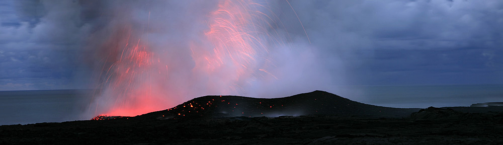
Are you exhausted from this long journey?? We have been 6’000 miles in space and over 85 ma in time, and we have arrived, back here, at Kilauea, arguably the most active volcano on earth, with two eruptive eruptions right at this time – from the summit at Halema’uma’u crater and from its eastern rift zone at Pu’u O’o crater, ongoing since 1983, which also is a world record on its own. We are back in the present time, and here are some fascinating impressions of what you can discover during your real, not fictitious journey, through Hawai’ Volcanoes National Park.
6. Outlook and End:
Now that we have made it full circle back to the visitors center at the summit of Kilauea here (show on map), I want to offer you a brief outlook into the future. I have alluded to it before: Time and space are invariably connected to each other. In fact, time is considered often to be the fourth dimension besides the three dimensions that we have in space (show with arm movements). So lets follow the line of volcanoes here (show on chart), and we will arrive in the middle of the ocean here. This is the place where the next Hawai’ian island is currently being born – it is not quite yet an island. The name is Lo’ihi, and it is currently a seamount – an underwater volcano. Lo’ihi means “Far in time” in Hawai’ian, and if the current eruptive activity keeps on going at its present state, it will be probably another 600’000 years before it will surface as an island above the sea water line – but it has already progressed 13’000 ft up from the sea bottom surrounding it! With that, I would like to thank you for coming over and listening to me, and I’d like to send you out to your own journey, discovering the beauty of the park and its ever changing landscape. As you now know: A journey in time and space!